Benbow KOA
7000 Benbow Drive
Garberville, CA 95542
707-923-2777
www.benbowrv.com, or koa.com/campgrounds/benbow
| Directions | Take Highway 101 to the Benbow exit, which is about two miles south of Garberville. |
| Reservations | 800-562-7518 |
| Fees | |
| Number of Spaces | |
| Check In Time | 1:00 pm |
| Cheeck Out Time | 12:00 pm |
| Generator Hours | |
| WiFi | Limited |
| Cell Phone Reception | |
| Documents | Brochure, rates |
| Campground Facilities | Camp Site Facilities | ||
| Dump Station | Fire Pit | ||
| Restrooms | ✓ | Picnic Table | |
| Showers | ✓ | Electricity | 30 and 50 amp |
| Water | ✓ | Sewer | ✓ |
| Garbage | ✓ | Water | ✓ |
| Recycling | ✓ | Cable | ✓ |
| Other | Grocery, laundry, pool, 9-hole golf course, pickle ball cabins | Paved | |
| Level | ✓ | ||
Casa de Fruta

10021 Pacheco Pass Highway
Hollister, CA 95023
408-842-9316
Casa de Fruta is a large rest area on Highway 152 with a fruit stand, store, restaurant, gas station, Inn, and RV park. The RV park and spaces are paved and level, but the asphalt is old and bumpy.
| Directions | Casa de Fruta is on Highway 152 east of Hollister. |
| Reservations | 408-842-9316 |
| Fees | $55-$65 (Good Sam) |
| Number of Spaces | 300 spaces: about half for long term residents, the rest for short term stays. |
| Check In Time | 1:00 pm |
| Check Out Time | 1:00 pm |
| Generator Hours | Not allowed |
| WiFi | Network name: "Casa de Fruta wifi"; no password |
| Cell Phone Reception | Good |
| Documents | Brochure, rates, restaurant menu |
| Campground Facilities | Camp Site Facilities | ||
| Dump Station | By exit from campground | Fire Pit | Some |
| Restrooms | ✓ | Picnic Table | ✓ |
| Showers | ✓ | Electricity | 110v, 30a, 50a |
| Water | ✓ | Sewer | ✓ |
| Garbage | ✓ | Water | ✓ |
| Recycling | Cable | ✓ | |
| Other | Pool, laundry, restaurant, inn, gas station with diesel, food mart, fruit stand, playground. | Paved | ✓ |
| Level | ✓ | ||
Costanoa (Santa Cruz KOA)
2001 Rossi Road
Pescadero, CA 94060
877-262-7848
Costanoa is the KOA campground north of Santa Cruz.
Coyote Lake County Park

10840 Coyote Lake Rd
Gilroy, CA 95020
408-842-7800
parks.santaclaracounty.gov/locations/coyote-lake-harvey-bear-ranch-county-park
Coyote Lake Harvey Bear Ranch County Park is a 6,695-acre regional recreation area, nestled in the hills east of Gilroy, CA.
The entire park is very well maintained. The access road is only a mile long, but it is narrow and winding.
| Directions | Take US-101 to Masten Ave, exit 360, in San Martin. Turn left onto Masten Ave (east). Turn right onto Center Ave, left onto Rucker Ave, right onto New Ave, and left onto Roop Road. Stay on Roop Road until you reach Coyote Lake Road on the left. |
| Reservations | Online at GoOutsideAndPlay.org. |
| Fees | $37 camp sites, $48 RV sites |
| Number of Spaces | 55 camp sites, 18 RV sites |
| Check In Time | 3:00pm - Do not arrive before check-in time; it costs $6 to wait in the overflow parking area. |
| Cheeck Out Time | 1:00pm |
| Generator Hours | |
| WiFi | No |
| Cell Phone Reception | Yes. The phone works, but I cannot connect my phone as a hotspot. |
| Documents | Map |
| Campground Facilities | Camp Site Facilities | ||
| Dump Station | On the right after leaving the park. | Fire Pit | ✓ |
| Restrooms | Very clean | Picnic Table | ✓ |
| Showers | Very clean | Electricity | 110v, 30a, 50a |
| Water | ✓ | Sewer | |
| Garbage | ✓ | Water | ✓ |
| Recycling | Cable | ||
| Other | Paved | ✓ | |
| Level | RV campsites are level and paved. Non-RV campsites are not as level. | ||
Gros Ventre Campground

Gros Ventre Campground Road
Grand Teton National Park, WY 83012
877-444-6777
www.recreation.gov/camping/campgrounds/247661
Gros Ventre Campground Road in Grand Tetons is ...
| Directions | |
| Reservations | Go online at www.recreation.gov. |
| Fees | Seniors with Interagency Senior Pass get half price on the campground fee. |
| Number of Spaces | |
| Check In Time | 12:00 pm |
| Cheeck Out Time | 11:00 am |
| Generator Hours | Generators are allowed in loops A, B, C, EC (East Corridor) Quiet hours are 10:00 pm to 8:00 am. |
| WiFi | |
| Cell Phone Reception | |
| Elevation | |
| Documents |
| Campground Facilities | Camp Site Facilities | ||
| Dump Station | Across from the campground entrance. | Fire Pit | ✓ |
| Restrooms | Flush toilets | Picnic Table | ✓ |
| Showers | ✓ | Electricity | Some sites |
| Water | ✓ | Sewer | |
| Garbage | ✓ | Water | |
| Recycling | Cable | ||
| Other | Paved | ||
| Level | |||
Half Moon Bay State Beach

95 Kelly Ave
Half Moon Bay, CA 94019
650-726-8820
Half Moon Bay State Beach is right on the beach with miles of sandy beach and bike trails that go all the way to the yacht harbor. Although, you cannot see the ocean from the campsites because of the sand dunes. The park and spaces are paved and level. There is a farm just outside the park on Kelly Avenue that sells fresh produce, and there is a New Leaf market about one mile away at the shopping area on Highway 92.
| Directions | Take Highway 92 to Half Moon Bay. When you get to the signal at Highway 1, turn left. Go to next signal, Kelly Ave., and turn right. The park is at the end of the street (about 1/2 mile). |
| Reservations | Online at Reserve California. There is an $8 fee for making a reservation. One night limit without reservation. Reservations are only accepted 48 hours or more in advance. |
| Fees |
$65 for premium spaces closest to ocean with 50 amp electricity, $50 for spaces further back
with 50 amp electricity, and $35 for spaces without electricity and furthest from ocean.
$2 discount for seniors Premium spaces $65: 16, 17, 19, 22, 24, 26, 30, 32 Regular spaces $50: 1, 3, 5, 7, 9-12, 18, 20, 21, 23, 25, 27, 29, 31, 33, 35, 39, 40, 42, 45-50 Regular space without electricity $35: 2, 4, 6, 8, 13, 14, 43 Handicapped spaces: 15, 28, 34, 44 |
| Number of Spaces | 46 spaces for motorhomes up to 40 feet in length. |
| Check In Time | 2:00 pm |
| Cheeck Out Time | 12:00 pm |
| Generator Hours | 10:00 am to 8:00 pm |
| WiFi | Network name: "ParksWiFi", no password. |
| Cell Phone Reception | Good |
| Documents | Brochure, rates, campground map |
| Campground Facilities | Camp Site Facilities | ||
| Dump Station | $10 | Fire Pit | ✓ |
| Restrooms | ✓ | Picnic Table | ✓ |
| Showers | ✓ | Electricity | Some spaces have 50 amp. |
| Water | ✓ | Sewer | |
| Garbage | ✓ | Water | |
| Recycling | Cable | ||
| Other | Paved | ✓ | |
| Level | ✓ | ||
Indian Flat

9988 Highway 140
El Portal, CA 95318
209-379-2339
Indian Flat is a small, private RV park 12 miles from the entrance to Yosemite National Park. Many spaces are under shade trees; others get full sun at least part of the day (which can be very hot in the summer). The spaces are very close together.
- Directions: Take Highway 140 east from Merced. Continue east through Mariposa. The campground is 22 miles from Mariposa and about 10 miles before the entrance to Yosemite near the town of El Portale. It will be on your right just past the Cedar Lodge.
- Fees: $42 from April to October, and $37 from November to March
- Number of Spaces: 25 spaces for motorhomes of various sizes.
- Facilities: Water, electricity, cable TV, picnic table and BBQ in all spaces. A few spaces have sewer. There is a dump station that costs $5 to use. You are allowed to use the swimming pool at Cedar Lodge next door.
- WiFi: There is public WiFi at Cedar Lodge next door, but I could not get it to work. No cell phone coverage (but there is in Yosemite Valley)
- Campground map
Joseph Grant County Park

Address
CityStateZip
Phone
Joseph Grant County Park is ...
| Directions | |
| Reservations | |
| Fees | |
| Number of Spaces | |
| Check In Time | |
| Cheeck Out Time | |
| Generator Hours | |
| WiFi | |
| Cell Phone Reception | |
| Documents |
| Campground Facilities | Camp Site Facilities | ||
| Dump Station | ✓ | Fire Pit | |
| Restrooms | Picnic Table | ✓ | |
| Showers | Electricity | ||
| Water | Sewer | ||
| Garbage | Water | ||
| Recycling | Cable | ||
| Other | Paved | ||
| Level | |||
MacKerricher State Park

24100 MacKerricher Park Road
Fort Bragg, CA 95437
707-937-5804
MacKerricher State Park is a very scenic area with lake, beach, and ocean.
- Directions: Three miles north of Fort Bragg on Highway 1
- Fees: $35
- Number of Spaces: 140 sites, but sections of the campground are closed in the winter.
- Facilities: Picnic tables, fire rings, and food lockers at each site. Restrooms with flush toilets, coin operated showers, water, WiFi, and dump station.
- Reservations: Accepted from April to September; otherwise, first come first serve. Make reservations online at Reserve California. There is an $8 fee for making a reservation. One night limit without reservation. Reservations are only accepted 48 hours or more in advance.
- Brochure, campground map
Mad River Rapids RV Park

3501 Janes Road
Arcata, CA 95521
707-822-7275
Mad River Rapids RV Park is nice, well maintained RV park with convenient freeway access.
| Directions | At the north end of Arcata on highway 101, take the Giuntoli Lane/Janes Road exit and go west for two blocks. The RV park will be on your left just past the Ramada Motel. |
| Reservations | 800-822-7776 |
| Fees | $64 (Good Sam discount) |
| Number of Spaces | 92 paved and level sites. Most spaces are pull through. |
| Check In Time | 12:00 pm |
| Cheeck Out Time | |
| Generator Hours | |
| WiFi | Yes |
| Cell Phone Reception | Good |
| Documents | Campground map |
| Campground Facilities | Camp Site Facilities | ||
| Dump Station | Fire Pit | ||
| Restrooms | ✓ | Picnic Table | ✓ |
| Showers | ✓ | Electricity | 30 and 50 amp |
| Water | ✓ | Sewer | ✓ |
| Garbage | ✓ | Water | ✓ |
| Recycling | Cable | ✓ | |
| Other | Mini-mart, laundry | Paved | ✓ |
| Level | ✓ | ||
Manresa State Beach
831-724-3750
- Number of Spaces: Tent camping only; no RVs.
- Directions: From Highway 1, south of Aptos, San Andreas Road heads southwest and continues for several miles to Manresa, the first beach access upon reaching the coast.
- Reservations: Online at Reserve California. There is an $8 fee for making a reservation. One night limit without reservation. Reservations are only accepted 48 hours or more in advance.
- Brochure, campground map
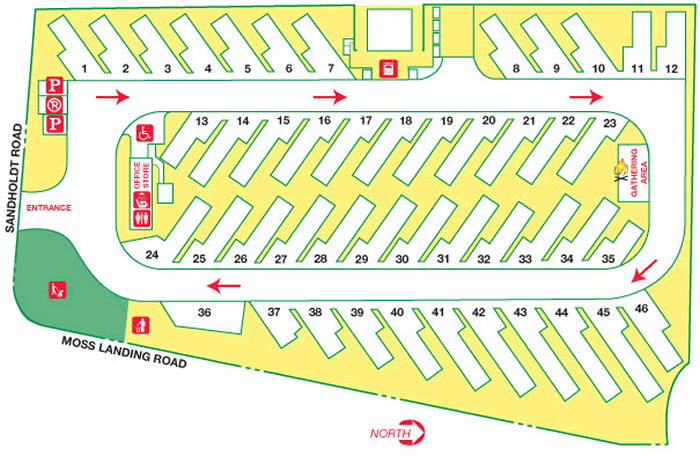
Moss Landing KOA

7905 Sandholdt Road
Moss Landing, CA 95039
800-562-3390
- Number of Spaces: 46
- Directions: Moss Landing KOA is in Moss Landing just off Highway 1 to the west. It is at the corner of Moss Landing Road and Sandholdt Road.
- Reservations: Online at Moss Landing KOA
- Brochure, campground map
Mount Madonna County Park
7850 Pole Line Road
Watsonville, CA 96076
408-842-2341, 408-299-2311
parks.sccgov.org/santa-clara-county-parks/Mt.Madonna-county-park
Mount Madonna County Park is a Santa Clara county park. There are sites for tents and RVs. The RV sites have water and electricity and are $44. The test sites are $34. I did not see any RVs using the text sites. Many of the sites are not very level.
Site 104RV had both electricity and water, however, the electric voltage dropped below 104v when the load was 8 amps of more. This caused the electricity in the RV to shut off and on. The water pressure was too low for the water heater to turn on in my RV. I don't know if all RV sites have these problems.
| Directions | The park is located on Highway 152 (Hecker Pass Highway), ten miles west of Gilroy. From the east, use Highway 101 and take the Highway 152 west exit. From the west, use Highway 1, and take the Highway 152 east exit. The entrance to the park is located at the summit of Highway 152 at Pole Line Road. |
| Reservations | Phone 408-355-2201, Monday-Friday, 8:30am-12:00pm or 1:00pm-4:00pm. Or, go onloine at Santa Clara County Parks home page. |
| Fees | $34, for tent sites, $44 for RV sites |
| Number of Spaces | |
| Check In Time | 3:00 pm |
| Cheeck Out Time | 1:00 pm |
| Generator Hours | |
| WiFi | No |
| Cell Phone Reception | No |
| Documents |
| Campground Facilities | Camp Site Facilities | ||
| Dump Station | ✓ | Fire Pit | ✓ |
| Restrooms | ✓ | Picnic Table | ✓ |
| Showers | ✓ | Electricity | ✓ |
| Water | ✓ | Sewer | |
| Garbage | ✓ | Water | ✓ |
| Recycling | Cable | ||
| Other | Paved | ||
| Level | |||
New Brighton State Beach
Park Avenue off Hwy. 1
Capitola, CA 95010
831-464-6329
- Directions: New Brighton State Beach is in the town of Capitola, just south of Santa Cruz. Take the New Brighton/Park Avenue exit off Highway 1.
- Reservations: Online at Reserve California. There is an $8 fee for making a reservation. One night limit without reservation. Reservations are only accepted 48 hours or more in advance.
- Brochure, campground map
Pfeiffer Big Sur State Park
47225 Highway 1
Big Sur, CA 93920
831-667-2315
Pillar Point RV Park
4000 Cabrillo Highway
Half Moon Bay, CA 94019
650-712-9277
newradio.com/pillarpointrvpark
- Directions: About ¼ mile south of the harbor entrance on highway 1.
- Fees: $67-84
- Number of Spaces: xxx spaces for motorhomes up to xx feet in length.
- Reservations: None. First come, first serve
- Highlights: Right on the ocean; beautiful view; walking distance to harbor and restaurants.
Pinnacles National Park Campground

2400 HWY 146
Paicines, CA 95043
831-200-1722
Pinnacles is ...
| Directions | |
| Reservations | recreation.gov |
| Fees | $41 non-electric, $59 electic |
| Number of Spaces | 134 |
| Check In Time | 1:00 pm |
| Cheeck Out Time | 11:00 am |
| Generator Hours | None |
| WiFi | Near the store |
| Cell Phone Reception | Near the store |
| Documents |
| Campground Facilities | Camp Site Facilities | ||
| Dump Station | ✓ | Fire Pit | ✓ |
| Restrooms | ✓ | Picnic Table | ✓ |
| Showers | At the pool | Electricity | 30 amp at RV sites |
| Water | ✓ | Sewer | |
| Garbage | ✓ | Water | |
| Recycling | ✓ | Cable | |
| Other | Store, 9:30-5:00 everyday | Paved | |
| Level | |||
Sanborn County Park

Address
CityStateZip
Phone
Sanborn County Park is ...
| Directions | |
| Reservations | |
| Fees | |
| Number of Spaces | |
| Check In Time | |
| Cheeck Out Time | |
| Generator Hours | |
| WiFi | |
| Cell Phone Reception | |
| Documents |
| Campground Facilities | Camp Site Facilities | ||
| Dump Station | ✓ | Fire Pit | |
| Restrooms | Picnic Table | ✓ | |
| Showers | Electricity | ||
| Water | Sewer | ||
| Garbage | Water | ||
| Recycling | Cable | ||
| Other | Paved | ||
| Level | |||
Seacliff State Beach
201 State Park Drive
Aptos, CA 95003
831-685-6500
- Directions: Take the State Park Drive exit from Highway 1. Proceed west through the neighborhood of Aptos to the entrance.
- Reservations: Online at Reserve California. There is an $8 fee for making a reservation. One night limit without reservation. Reservations are only accepted 48 hours or more in advance.
- Brochure, campground map
Sunset State Beach

201 Sunset Beach Road
Watsonville, CA 95076
831-763-7063
Sunset State Beach is on a hill overlooking the beach below. You cannot see the beach from the campsites, but it is a short walk to the edge of the hill overlooking the beach and a half mile or so to the beach itself. There is a parking lot at the beach for daytime use.
The Campground is divided into three areas: the South Camp (1-37), which is the southern most loop or furthest from the entrance, then the Pine Hollow Camp (38-61), and Dumes Camp (62-90), which is the northern most loop. The Dumes Camp and Pine Hollow Camp are closed during the off season.
Dunes Camp
All the spaces in the Dunes Camp have a paved area for parking. Most are fairly level. 68, 69, 71, and 86 are almost flat. 66 and 67 are not very level. 80 is for handicapped only.
Pine Hollow Camp
The spaces in Pine Hollow Camp are dirt and mostly uneven, but nothing too severe.
South Camp
Most spaces in South Camp are not very level, but 8-10, 34, 35 may be too unlevel for a motorhome to park comfortably. Spaces 23-25 have a slight view of the ocean and are the nicest spaces. When reserving a site, look at the pad length, not the site length (don't know what this means; it's always 31 feet). Spaces 3-4 are too short for an RV (20 feet) unless it backs in and overhangs the back of the RV into the campsite.
| Directions | The beach is 16 miles south of Santa Cruz. From Hwy 1 take the San Andreas Road exit. Proceed south to Sunset Beach Rd; go west to beach entrance. |
| Reservations | Online at Reserve California. There is an $8 fee for making a reservation. One night limit without reservation. Reservations are only accepted 48 hours or more in advance. |
| Fees | $35 for allspaces. |
| Number of Spaces | 90 spaces for motorhomes up to 31 feet in length. |
| Check In Time | 2:00 pm |
| Cheeck Out Time | 12:00 pm |
| Generator Hours | 10:00 am - 8:00 pm |
| WiFi | No |
| Cell Phone Reception | Yes. The phone works, but I cannot connect my phone as a hotspot. |
| Documents | Brochure, campground map |
| Campground Facilities | Camp Site Facilities | ||
| Dump Station | Camping fee allows you to use the dump station at New Brighton State Beach | Fire Pit | ✓ |
| Restrooms | ✓ | Picnic Table | ✓ |
| Showers | 2 quarters for 2 minutes | Electricity | |
| Water | Sewer | ||
| Garbage | Water | ||
| Recycling | Cable | ||
| Other | Paved | ||
| Level | |||
Uvas Canyon County Park

Address
CityStateZip
Phone
Uvas Canyon County Park is ...
| Directions | |
| Reservations | |
| Fees | |
| Number of Spaces | |
| Check In Time | |
| Cheeck Out Time | |
| Generator Hours | |
| WiFi | |
| Cell Phone Reception | |
| Documents |
| Campground Facilities | Camp Site Facilities | ||
| Dump Station | ✓ | Fire Pit | |
| Restrooms | Picnic Table | ✓ | |
| Showers | Electricity | ||
| Water | Sewer | ||
| Garbage | Water | ||
| Recycling | Cable | ||
| Other | Paved | ||
| Level | |||
Uvas Pines RV Park
13210 Uvas Road
Morgan Hill, CA
408-779-3417
- Directions:
- Fees: $75-80
- Number of Spaces: xxx spaces for motorhomes up to xx feet in length.
- Facilities: Water, electricity, and sewer in all spaces. Dump station and propane available.
- WiFi: Yes
Westport Beach RV Park

37700 North Hwy 1
Westport, CA 95521
707-964-2964
www.CasparBeachRVPark.com/Westport.html
- Directions: 16 miles north of Fort Bragg and 1 mile north of Westport on the west side of Highway 1.
- Fees: $44 without hookups, $58 with hookups, $65 with hookups, premium site (creek side or ocean front)
- Number of Spaces: 75
- Facilities: Picnic tables and fire rings at each site. Hookups at some site. Restrooms with flush toilets, coin operated showers and laundry, water, WiFi, store and recreation facilities.
- Reservations: Online or call 707-964-2964.
- Campground map, rates
Westport-Union Landing State Beach

707-937-5804
Westport-Union Landing State Beach is a primitive campground, but it is on a bluff right next to the ocean. This is a long thin park that stretches for a couple miles along Highway 1. There are 3 entrances. From south to north they are Abalone, the main entrance, and the Howard Creek entrance. The Abalone section is closed in the winter.
- Directions: 19 miles north of Fort Bragg and 2 miles north of Westport on the west side of Highway 1.
- Fees: $25
- Number of Spaces: 85
- Facilities: Picnic tables and fire rings at each site. Drinking water and pit toilets are available.
- Reservations: Not accepted.
Yosemite, Hodgdon Meadow Campground

PO Box 577
Yosemite National Park, CA 95389
209-372-0200
www.nps.gov/yose/planyourvisit/campgrounds.htm
The Hodgdon Meadow campground near Yosemite Valley is open all year.
- Directions: The Hodgdon Meadow Campground is just past the Big Oak Flat Entrance Station to Yosemite National Park. From the Big Oak Flat entrance station, go south ½ mile on Highway 120 (Big Oak Flat Road). Turn left (east) on Tuolumne Grove Road. In 2500 feet, the campground will be on your right. Yosemite Valley is 25 miles further south. Take Highway 120 south, but go straight at Crane Flat, which is where Highway 120 turns left to cross the Tioga pass.
- Fees: $28 plus park entrance fee. Seniors with Interagency Senior Pass get free entry into the park and half price on the campground fee.
- Number of Spaces: 31 spaces for motorhomes. Size restrictions vary by campsite.
- Facilities: No hookups; There are bathrooms with flush toilets (not especially clean because of high usage). No fresh water except in the bathrooms.
- Condition: Within the campground, both the roads and campsites are dirt. Campsites are generally not level.
- Elevation: 4875 feet
- WiFi: None
- Cell Reception: None
- Reservations: Required in the peak season. To make a reservation call 877-444-6777 or go online at www.recreation.gov.
- Campground map
Yosemite, Lower Pines Campground

9024 Southside Drive
Yosemite National Park, CA 95389
209-372-8502
www.nps.gov/yose/planyourvisit/campgrounds.htm
The Lower Pines Campground in Yosemite Valley is open from April to October. There are two adjacent campgrounds, North Pines and Upper Pines. Upper Pines is open all year.
- Directions: The Lower Pines Campground is at the eastern end of Yosemite Valley. There are three roads that lead to Yosemite Valley. Highway 120 from Manteca is the northern most approach. Highway 140 leads to Yosemite Valley from Merced and Mariposa. Highway 41 from Fresno is the southern most approach. It enters the park at Wawona and continues north to Yosemite Valley.
- Fees: $28 plus park entrance fee. Seniors with Interagency Senior Pass get free entry into the park and half price on the campground fee.
- Number of Spaces: ??? spaces for motorhomes. Size restrictions vary by campsite. Sites are level; most are paved but some are not.
- Facilities: No hookups; There is fresh water and bathrooms with flush toilets. There is a dump station just outside the entrance to the North Pines Campground. There is cell phone coverage in Yosemite Valley.
- WiFi:There is free WiFi at Degnan's deli in Yosemite Village. The access code is "welcome1".
- Elevation: 4000 feet
- Reservations: Required. To make a reservation call 877-444-6777 or go online at www.recreation.gov.
- Campground map
Yosemite, North Pines Campground

9024 Southside Drive
Yosemite National Park, CA 95389
209-372-8502
www.nps.gov/yose/planyourvisit/campgrounds.htm
The North Pines Campground in Yosemite Valley is open from April to October. There are two adjacent campgrounds, Lower Pines and Upper Pines. Upper Pines is open all year.
- Directions: The North Pines Campground is at the eastern end of Yosemite Valley. There are three roads that lead to Yosemite Valley. Highway 120 from Manteca is the northern most approach. Highway 140 leads to Yosemite Valley from Merced and Mariposa. Highway 41 from Fresno is the southern most approach. It enters the park at Wawona and continues north to Yosemite Valley.
- Fees: $28 plus park entrance fee. Seniors with Interagency Senior Pass get free entry into the park and half price on the campground fee.
- Number of Spaces: ??? spaces for motorhomes. Size restrictions vary by campsite. Sites are level; some are paved but most are not.
- Facilities: No hookups; There is fresh water and bathrooms with flush toilets. There is a dump station just outside the entrance to the North Pines Campground. There is cell phone coverage in Yosemite Valley.
- WiFi:There is free WiFi at Degnan's deli in Yosemite Village. The access code is "welcome1".
- Elevation: 4000 feet
- Reservations: Required. To make a reservation call 877-444-6777 or go online at www.recreation.gov.
- Campground map
Yosemite, Upper Pines Campground

9024 Southside Drive
Yosemite National Park, CA 95389
209-372-8502
www.nps.gov/yose/planyourvisit/campgrounds.htm
The Upper Pines Campground in Yosemite Valley is open all year. There are two adjacent campgrounds, Lower Pines and North Pines, that are only open from April through October. For Yosemite road conditions call 209-372-0200, #1, #1.
| Directions | The Upper Pines Campground is at the eastern end of Yosemite Valley. There are three roads that lead to Yosemite Valley. Highway 120 from Manteca is the northern most approach. Highway 140 leads to Yosemite Valley from Merced and Mariposa. Highway 41 from Fresno is the southern most approach. It enters the park at Wawona and continues north to Yosemite Valley. |
| Reservations | Necessary in the peak season and recommended in the off season. To make a reservation call 877-444-6777 or go online at www.recreation.gov. |
| Fees | $28 plus park entrance fee. Seniors with Interagency Senior Pass get free entry into the park and half price on the campground fee. |
| Number of Spaces | 230 spaces for motorhomes. Size restrictions vary by campsite. |
| Check In Time | |
| Cheeck Out Time | 12:00 pm |
| Generator Hours | 7:00 am to 9:00 am, 12:00 pm to 2:00 pm, and 5:00 pm to 7:00 pm |
| WiFi | There is free WiFi at Degnan's deli in Yosemite Village. The access code is "welcome1". |
| Cell Phone Reception | In various places in the park, but not everywhere. |
| Elevation | 4000 feet |
| Documents | Campground map |
| Campground Facilities | Camp Site Facilities | ||
| Dump Station | Outside the entrance to Upper Pines campground. | Fire Pit | ✓ |
| Restrooms | Flush toilets | Picnic Table | ✓ |
| Showers | ✓ | Electricity | |
| Water | ✓ | Sewer | |
| Garbage | ✓ | Water | |
| Recycling | ✓ | Cable | |
| Other | Pay phone, shuttle bus, campground host in sites 50 and 52. | Paved | Some |
| Level | Mostly | ||
Yosemite, Wawona Campground

9024 Southside Drive
Yosemite National Park, CA 95389
209-372-8502
www.nps.gov/yose/planyourvisit/campgrounds.htm
The Wawona Campground near the southern entrance to Yosemite is open from April to October. For Yosemite road conditions call 209-372-0200, #1, #1.
Campsites that accomodate 25' motorhomes.
- Site 009, loop A, 27'
- Site 010, loop A, 35'
- Site 011, loop A, 35'
- Site 012, loop A, 24'
- Site 015, loop A, 27'
- Site 016, loop A, 27'
- Site 017, loop A, 35'
- Site 018, loop A, 27'
- Site 019, loop A, 27'
- Site 021, loop A, 35'
- Site 022, loop A, 35'
- Site 023, loop A, 35'
- Site 024, loop A, 21'
- Site 025, loop A, 35'
- Site 026, loop A, 22'
- Site 032, loop B, 22'
- Site 036, loop B, 22'
- Site 037, loop B, 22'
- Site 043, loop B, 30'
- Site 053, loop C, 35'
- Site 054, loop C, 35'
- Site 057, loop C, 24'
- Site 058, loop C, 24'
- Site 059, loop C, 24'
- Site 060, loop C, 24'
- Site 063, loop C, 27'
- Site 064, loop C, 27'
- Site 065, loop C, 27'
- Site 066, loop C, 27'
- Site 068, loop C, 27'
- Site 072, loop C, 35'
- Site 073, loop C, 35'
- Site 074, loop C, 35'
- Site 075, loop C, 35'
- Site 076, loop C, 27'
| Directions | The Wawona Campground is near the southern entrance of Yosemite. From the South Entrance drive 6 miles north on the Wawona Road (Highway 41); approximately 1 mile north of Wawona, the campground is located on the left. From Yosemite Valley, drive south 27 miles (approximately 45 minutes) and just before you reach Wawona itself, the campground will be on the right. There are three roads that lead to Yosemite Valley. Highway 120 from Manteca is the northern most approach. Highway 140 leads to Yosemite Valley from Merced and Mariposa. Highway 41 from Fresno is the southern most approach. Highway 41 within Yosemite connects Yosemite Valley and the southern entrance. |
| Reservations | Are always needed, but you can call or go to the campground reservation office near Curry Village to check on availability. To make a reservation call 877-444-6777 or go online at www.recreation.gov. |
| Fees | $28 plus park entrance fee. Seniors with Interagency Senior Pass get free entry into the park and half price on the campground fee. |
| Number of Spaces | xxx spaces for motorhomes. Size restrictions vary by campsite, but 35 feet is the largest RV allowed. |
| Check In Time | |
| Cheeck Out Time | 12:00 pm |
| Generator Hours | 7:00 am to 9:00 am, 12:00 pm to 2:00 pm, and 5:00 pm to 7:00 pm |
| WiFi | No |
| Cell Phone Reception | No |
| Elevation | 4000 feet |
| Documents | Campground map |
| Campground Facilities | Camp Site Facilities | ||
| Dump Station | Past the parking lot at the Wawona Hotel. | Fire Pit | ✓ |
| Restrooms | Flush toilets | Picnic Table | ✓ |
| Showers | ✓ | Electricity | |
| Water | ✓ | Sewer | |
| Garbage | ✓ | Water | |
| Recycling | ✓ | Cable | |
| Other | Paved | ||
| Level | Mostly | ||